 NetMap's Virtual Watersheds & Smart River Networks
A Virtual Watershed is a geospatial simulation of riverine landscapes used to enumerate watershed landforms and processes, and human interactions over a range of scales.
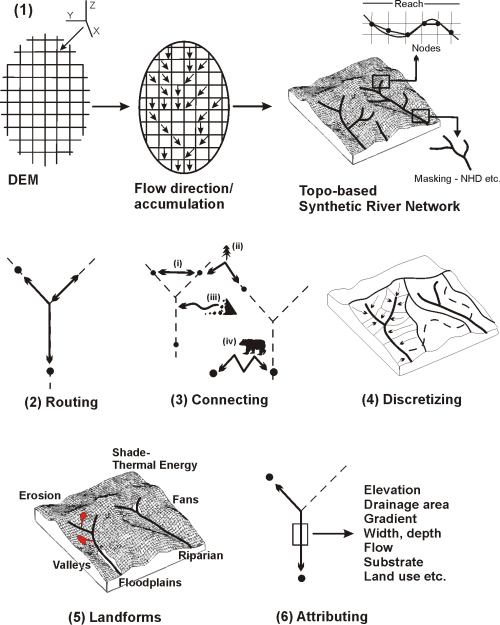
A Virtual Watershed includes (1) smart, synthetic river networks and the highest resolution digital elevation models, couples them together, and then adds five types of analytical capabilities, including:
2) routing information downstream and upstream,
3) connecting river networks to terrestrial environments,
4) discretizing landscapes and land uses into facets of appropriate scales to identify interactions,
5) characterizing landforms and
6) attributing river segments with key stream and watershed information.
They are customizable and adaptable to specific needs.
See differences between 10 m DEMs and LiDAR.
Analytical Features of Virtual Watersheds
Channel Hydraulic Geometry Floodplains Historical Floodplains
Stream Power/Substrate Sinuosity Stream Order
Define Fish Habitat Habitat Quality Habitat Diversity
Channel Classification Subbasin Classification Beaver Habitat
Thermal Sensitivity Shade/Thermal Energy Wood Recruitment
Thermal Refugia Delineate Riparian Zones Landslide Potential
Debris Flow Potential Gully Potential Surface Erosion, incl. Pre- & Post Fire
Sediment Delivery Road Drainage Diversion Road Stability
Road Surface Erosion/Delivery Habitat Length above Roads Roads in Floodplains
Wildfire Risk Cascade Climate Change Vulnerability Identify Highest Priorities
Applications
Forestry Riparian Management Slope Stability Roads/Pipelines
Floodplain Mapping Erosion/Sediment Budget Fisheries.Bio-Hotspots
Watershed Analysis Restoration Conservation Urban Planning
Monitoring Estuary Mapping Ecosystem Services Regulatory
Personalized Hazard Assessments Risk/Insurance Education
Research Wildfire-Pre Wildfire-Post Climate Change