
See NetMap's Riparian Management Tools
See an example of applying the riparian tools.
Delineate your own riparian zones.
See channel left - right riparian distinction for designing riparian buffers.
See how NetMap's river networks and virtual watersheds are being used in Spain to delineate riparian zones. Download summary paper.
Additional Background:
Designing Riparian Management at the Reach and Watershed Scales
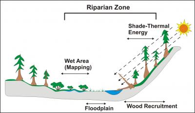
Riparian management is often concerned with protecting riparian habitats and the important interactions between the riparian and stream systems (sunlight, stream temperature, wood recruitment, stream bank erosion etc.).
TerrainWorks (NetMap) tools are designed specifically to address riparian management questions such as how riparian vegetation affects thermal loading (tool), affects wood recruitment at both the stream reach (project) and watershed scales (tools). NetMap's fish habitat, floodplain, valley mapping and confluence tools can also be used to determine the varying importance of riparian processes at the scale of entire watersheds.
TerrainWorks (NetMap) tools contains tools for addressing riparian management:
- thermal energy sensitivity
- effects of current shade on thermal energy
- in-stream wood recruitment - reach (project) scale
- in-stream wood recruitment - watershed (single year) scale
- thermal refugia (four types)
- floodplain mapping
- erosion potential
- fish habitat quality
- biological hotspots
 1) Intrinsic Thermal Sensitivity (which stream reaches are most sensitive to reduction of streamside vegetation).

In-stream thermal loading as a function of vegetation shade (and other physical properties of the watershed).
 2) Effects of Current Shade on Thermal Energy (or where increased Shade would be most effective).

Help with the design of buffer strips.
 Identify the highest priority sites for riparian restoration in terms of increasing shade.
 3) Map floodplains, including historical floodplains.
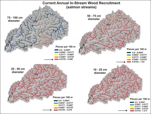 4) Watershed Scale In-stream Wood Recruitment. (Under current riparian forest conditions, calculate a single year's potential for in-stream wood recruitment; shown are results for the Nehalem Watershed in Northwestern Oregon.
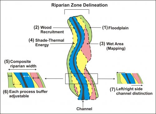 5) Delineate Riparian Zones
 See example from the Peace River, in Alberta
Another more detailed example of riparian zone management using NetMap tools.
Thinning in Riparian Second Growth Forests: A NetMap Model of In-stream Wood Recruitment for Evaluating Alternatives
To help inform one aspect of riparian management in second growth forests, we developed a model to evaluate effects of thinning on wood recruitment and effects of mitigation strategies including use of buffer strips and mechanical introduction of trees into streams. Application of the model is illustrated for an area in the central Oregon Coast Range.

To simulate stand growth and death the Northwest Oregon version of ORGANON was used, a growth-and-yield model tailored to even- and uneven-aged forest stands up to 120 years of age. ORGANON only simulates suppression (i.e., density-dependent) mortality and does not simulate tree regeneration. Simulations were run for 100 years using three different silvicultural prescriptions that reflect current management approaches in second growth forest plantations in the Siuslaw National Forest:
1) no treatment,
2) a single entry thin from below (thinning from below removes the smallest trees first to simulate suppression mortality), and
3) a double entry thin from below with the first one as described in (2) and the second one, 30 years later.
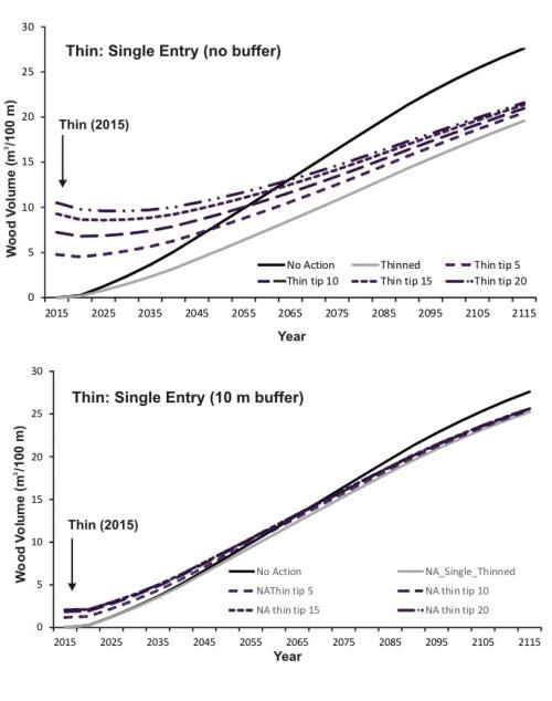
Results, single entry thin. There is a large reduction of instream wood (-35%) because of the thinning (on one side of the channel), compared to non thinned, second growth forests on both sides of the channel. The dashed lines show the input of wood from
tree tipping", the mechanical introduction of trees into the stream by directional felling (percentages refer to that portion of the thinned trees that were felled into the stream).

Results, double entry thin. There is a large reduction of instream wood (-42%) because of the thinning (on one side of the channel), compared to non thinned, second growth forests on both sides of the channel. The dashed lines show the input of wood from
tree tipping", the mechanical introduction of trees into the stream by directional felling (percentages refer to that portion of the thinned trees that were felled into the stream).
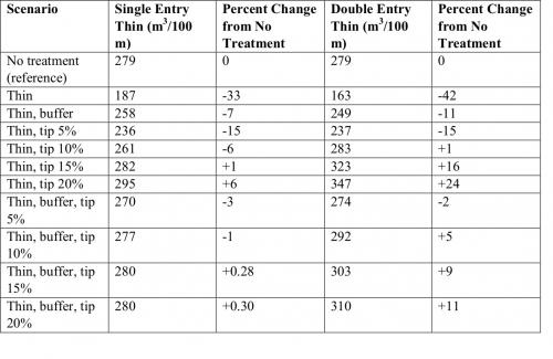
Table shows the percent difference among thinning with and without a 10 m buffer, thinning with tipping variable percents of the thinned trees into the stream (with and without a 10 m buffer).
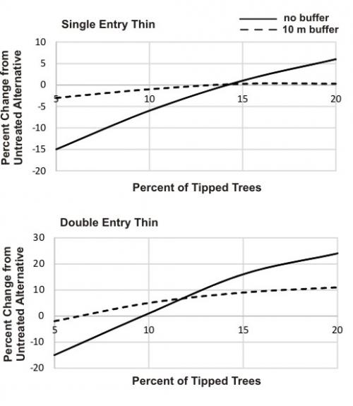
A graphical representation of the table. For a single entry thin (no buffer), tipping about 14% of the thinned trees eliminates the loss of instream wood from the thinning. For a double entry thin (no buffer), tipping 10% of the thinned trees eliminates the loss of instream wood from the thinning.
Learn more about the in-stream wood recruitment tool.