Spatially Explicit Riparian Management
Tools in TerrainWorks are used to support riparian management by evaluating how wide stream side buffer strips need to be to ensure adequate recruitment of wood to streams and to protect the stream from excessive thermal loading. In addition, thinning in riparian areas can lead to a reduction in wood recruitment.
TerrainWorks project level wood recruitment tool has the ability to calculate the loss of wood in streams that can result from thinning and then to further calculate how many of the thinned trees would need to be directionally felled into the stream to make up the difference, and hence to mitigate the effects of the thinning on wood loading.
These calculations can also be performed at the watershed scale.
In addition, TerrainWorks tools and parameters can be used to design a spatially explicit approach to riparian management and protection including mapping fish habitat quality and distribution, biological hotspots (using tools for floodplains and tributary confluenes), wood recruitment, thermal loading and erosion potential, including slope stability. Upslope sources of large wood to streams by mass wasting (landslides and debris flows) can also be estimated by TerrainWorks.
Transportation Planning (Roads)
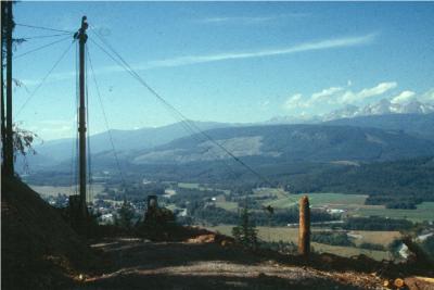
TerrainWorks contains a series of tools for advanced analysis of unpaved and paved road systems, and they can be used to create sophisticated management plans for transportation systems at the scale of national forests, state forests, parks, Department of Defense lands, and private property (e.g., timber companies, large ranches etc.). Although TerrainWorks watershed datasets often include a default road layer, users can import their own road layers into the datasets to work with the tools.
To see how TerrainWorks (NetMap) has been used in a road analysis, see here.
Road tools include:
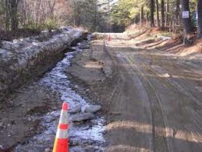 1) Road Drainage Diversion and Runoff. GIS road line segments are generally kilometers or miles long. NetMap, using DEM topography and the delineated synthetic stream network in its Digital Hydroscape, along with user provided data on drainage structure locations (or not), breaks the roads into hydrologically connected segments (either directly to streams or those draining onto non stream areas). Predicted road hydrologic connectivity can be used alone to determine where, in a watershed or within an entire road network, drainage diversion and runoff may be an impact (allowing focus of restoration). The predicted road drainage segment lengths are used in TerrainWorks prediction of road surface erosion and sediment delivery to streams (using WEPP and GRAIP-Lite technologies).
2) Road Surface Erosion. TerrainWorks contains two models to predict road surface erosion: WEPP for roads and GRAIP-Lite. Both models require estimates of road segment drainage length and slope (see above), road surface type and maintenance level, road dimensions and geometry, climate and distance of the road segment to the nearest stream. TerrainWorks calculates the distance of each individual road segment to each channel segment that it drains into.
3) Roads in Floodplains. The floodplain tool allows user to map floodplain extent at varying elevations about channels. Then all road segments that intersect floodplains are identified. All road segments with substantial drainage diversion and road surface erosion intersecting floodplains (and streams) can also be identified.
 4) Road Stability. It is not feasible by remote sensing alone (GIS) to accurately determine the stability of roads running along a hillslope, because little is known about the subsurface characteristics of road fills, cutslope geomechanics, and site specific vegetation conditions. In TerrainWorks, road stability is classified based on the predicted hillslope stability beneath the road. Various slope stability indices can be used.
5) Road Density. The density of road networks in a landscape (mi/mi2, km/km2) has been used as a proxy or index on the cumulative negative effect of roads on aquatic systems and also on wildlife. Conventionally, road density is calculated at the scale of polygons, typically a watershed. At this scale (tens to hundreds of square miles), road densities in forest lands are often in the range of 1 to 5 mi/mi2.
TerrainWorks calculates road density (and the density of road-stream crossings) at the scale of subbasins within individual watershed datasets. It also has the capability to calculate road density at the scale of individual slices of hillslope associated with individual stream reaches, referred to as “drainage wings”. Road density calculated at the individual stream segment-drainage wing scale can range from zero to greater than 100 mi/mi2 or km/km2. In this way, analysts can identify those hillslopes and stream reaches that have the very highest road density and likely the highest potential impacts from roads.
Other tools in TerrainWorks allow for searches between the highest road density (or highest drainage diversion, road erosion or road instability) and the most sensitive habitats. Refer to the “Overlap Tool” for additional information.
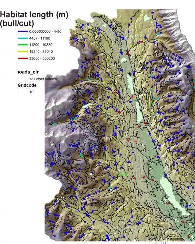 6) Cumulative Distance and Quality of Aquatic Habitat Upstream of Road Crossings.
Roads can function as barriers to fish migration because of culverts that are too steep (gradient barriers) or because there are elevation differences between culvert pipes and stream channels. For a comprehensive evaluation of roads, go here.
The Transportation or Roads Module in TerrainWorks allows analysts to make quick calculations about the length and quality of habitat upstream of every road crossing. This data could be used to help strategize which road – stream crossings should be updated or restored to allow for improved fish migration.
7) Road-Stream Crossing Classification. The main impact of roads on aquatic systems may occur at the locations where roads cross streams, and their influence diminishes with increasing distance of the road to the stream. Hence it may be useful to classify road-stream crossings by a number of variables including fish habitat quality, cumulative habitat length (above any road crossing), floodplain extent and habitat diversity etc.
Slope Stability
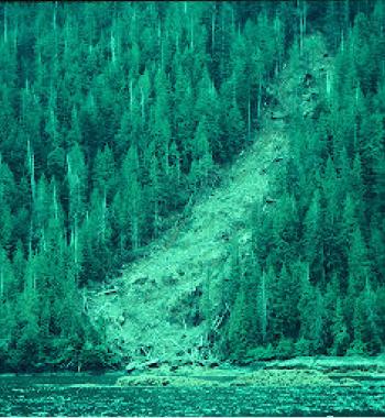
There are several slope stability models and indices in TerrainWorks that can be used in the context of forestry activities. Harvest of trees and construction of roads can destabilize hillsides and lead to impacts to aquatic resources.
Slope stability (erosion) indices include:
- Shallow failure
- Gullying
- Debris Flow
- Deep Seated Landslides/Earthflows

Maps of predicted slope stability can be used as a coarse screen from which to consider forestry (or other land use) activities. In addition, many of the tools consider the delivery of sediment to streams, including those fish bearing.
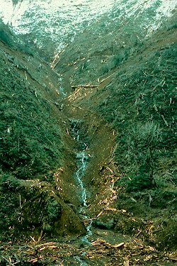
Thus, the tools can be used to evaluate future forestry operations but also past forestry practices.