 Conduct Climate Change Vulnerability Assessments
Effects of predicted climate change on hydrological and geomorphological processes relevant to ecosystems must be defined and widely disseminated to decision makers. TerrainWorks (NetMap) can aid in conducting climate change vulnerability assessments and allow scientists and planners to quickly identify specific basins, and portions of landscapes and rivers within them, that are at the highest risk for climate change impacts, allowing them to prioritize habitat enhancement or restoration activities.
See how NetMap can be used to understand landscape vulnerability.
See how NetMap was used in assessing climate change vulnerability in northern California.
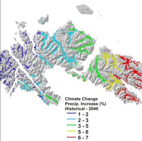
NetMap uses scenarios representing a composite average of ten global climate models (GCM) for the western US using four bracketing scenarios based on four GCMs (ECHAM5, MIROC_3.2, HADGEM1, and PCM1). Predictions are for one greenhouse gas scenario (A1B, a middle of the road scenario for future emissions). Results are in percent change from historical (1916-2006) to forecasts in 2040 for precipitation, snow accumulation, snow-water equivalent and summer and winter runoff. Changes in temperature are in absolute degree C. Forecasts are from University of Washington Climate Impacts Group. For additional background information on how forecasts were made, see here and here.
Climate change induced alterations to hydrologic and erosion regimes can add to other environmental stressors and can push salmon survival to the brink and beyond (Nelitz et al. 2007).
Habitat restoration measures could be designed to enhance salmon survival even in the face of altered flow and in-channel morphological conditions (Battin et al. 2007). Restoration activities such as reestablishing hydrological connectivity across streams and floodplains, restoring natural flow regimes and repairing aggraded channels have the potential to create a protective buffer between climate change impacts and salmon (Beechie et al. 2012).
 Use NetMap to quickly identify locations in a watershed or across landscapes where climate change impacts (based on downscaled climate change predictions) overlap with other stressors and sensitive aquatic habitats - at the scale of stream reaches.
For example, at what locations do the predicted changes in precipitation overlap with areas of the highest road density (another stressor) and where do those overlap with valuable and sensitive fish habitats in southeast Alaska?

Identifying overlaps between climate change stressors and salmon habitats will provide strategic information to enable forest planners and managers, and regulatory agenices, to make better informed climate change adaptation decisions, including: 1) increasing opportunities for forest restoration and road maintenance designed to increase slope stability, 2) protecting key stream-floodplain refugia habitats located in areas of predicted low flow, high flow or sedimentation stress (or some combination) and 3) restoring sections of rivers and floodplains that are located in areas predicted to be nexuses of climate change stressors.
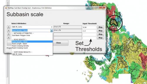
Analysts can use NetMap's Digital Hydroscape and Tools either at the stream reach scale or at the scale of entire watersheds or subbasins.