 Inform Conservation Strategies
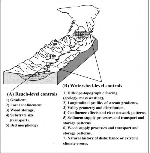
Use TerrainWorks (NetMap) Digital Landscapes and analysis tools to develop customized ecosystem classifications using both reach scale and watershed scale attributes.
TerrainWorks (NetMap) Digital Hydroscape and Tools are specifically designed to provide conservation planners with the information they need to develop watershed, landscape and even regional plans and to communicate their perspectives to a wider audience, including the public.
TerrainWorks can complement existing conservation planning tools including Trout Unlimited’s “Conservation Success Index (CSI)” and the Nature Conservancy’s Conservation Action Planning (CAP).

Identify the Most Valuable Habitats for Protection
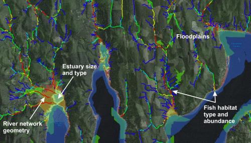
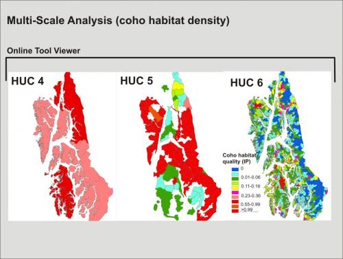
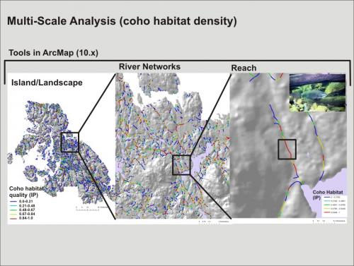
Use NetMap's Digital Hydroscape and suite of tools to identify the intrinsically best habitats at the scale of stream reaches to entire river networks. Use the Sort and Rank tool to classify entire watersheds or ecosystems based on distribution and quality of fish habitats.
Create Custom Ecological Classification
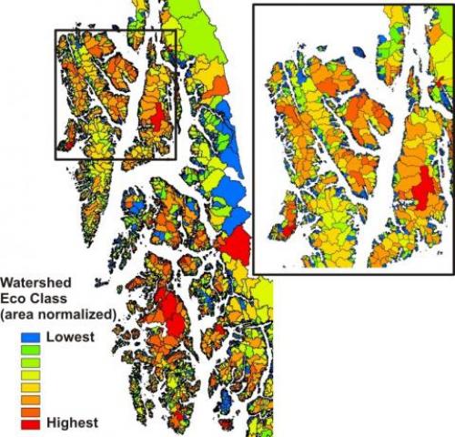
Create unique ecological classification schemes to support landscape to regional conservation planning. For example, in conjunction with the Tongass National Forest, NetMap was used to combine salmon habitat potential, floodplains, estuaries and tributary confluences to create a provisional watershed ecological classification system in the Alexander Archipelago, southeast Alaska
.
 For example, ithe Puget Sound, NetMap analysts could combine salmon habitat potential with floodplains and estuaries to build a multi faceted aquatic ecological classification.
 TerrainViewer: Your Portal into Regional Conservation Planning
Use the TerrainViewer to examine spatial patterns (and overlaps) among indices of ecosystem value and environmental stressors at multi scales ranging from entire states, landscapes, ecosystems, watersheds, jurisdictional boundaries like national forests and districts, and all the way down to individual stream and valley segments.
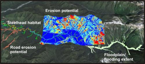
Once you identify valuable habitat for conservation, examine overlaps between stressors and conservation values.
TerrainWorks (NetMap) Conservation Oriented Projects:
Matanuska-Susitina Watershed in Alaska, Salmon Habitats (w/TNC)
Upper John Day watershed, restoration/conservation planning (w/Warm Springs Tribe)
Western Olympics, Washington, Salmon Habitats (w/WCSSP)
Oregon Coast Range, Coho delisting restoration analyses (w/NOAA)
Mapping salmonid habitats in far east Russia (Sakhalin Island); the Wild Salmon Center
Exploring integrating NetMap with Trout Unlimited’s CSI and Nature Conservancy’s CAP
Creating TerrainWorks Digital Landscapes covering all of western Olympic Peninsula for the Sustainable Salmon Partnership
Mapping salmonid habitats, floodplains and road density across western Oregon for the Nature Conservancy and Wild Salmon Center
Habitat restoration in the John Day Watershed (John Day Watershed Council
Developed fish habitat model for Chinook in the Copper River basin, Alaska (Ecotrust)
Worked with Colorado State University to develop an estuarine mapping procedure to develop a watershed ecological classification scheme
Conservation of Bull trout and Cutthroat trout habitat in northeastern Washington, Kalispel Tribe
Habitat mapping in the Puget Sound in support of conservation and restoration (EPA and the Puget Sound Partnership
