 Analyze Road Related Risk and Improved Road Management
Roads, particularly those that are unpaved, are often considered a major source of impacts. But through proper planning and maintenance, their effects on the environment can be significantly reduced. TerrainWorks (NetMap) contains a suite of tools that are used to address road related issues whether in national forests or in urban areas.
See PPT_PDF overview of road tools here.
See howNetMap's road tools can be used to address questions such as:
1) How have existing forest road practices reduced erosion and sediment
delivery to streams (e.g., getting credit)? and
2) Where, in the future, would one go to optimize the reduction of road erosion
and sediment delivery (e.g., maximizing cost benefit)? See the movie.
Similarly, energy pipelines (and drilling pads) pose a similar set of environmental issues. Pipelines often require parallel roads for construction and maintenance. They may also be prone to impacts from mass failure. Here again, TerrainWorks tools can be used to better manage the environmental consequences of energy pipelines.
TerrainWorks (NetMap) tools for roads and energy pipelines include:
- Road (or pipeline) density (either subbasin scale or individual hillside-stream segment scale)
- Road drainage diversion (e.g., hydrologic connectivity)
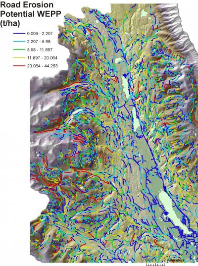
- Road surface erosion and sediment delivery to streams
- Road stability (landslide)
- Road related debris flow risk (initiation or impacted by)
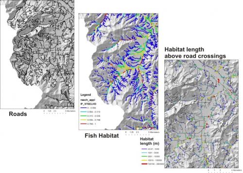
- Cumulative fish habitat length (and quality) above all road – stream crossings
- Roads in floodplains
- Road – aquatic classification
In TerrainWorks, roads are broken at pixel cell borders, creating a population of small segments from which to calculate various attributes such as road hydrologic connectivity (drainage diversion or piracy), road surface erosion, road stability and roads in floodplains. Individual segments can be aggregated to longer segments, as needed for different applications. Road data from TerrainWorks can be transferred back to the original road layers (such as US Forest Service or BLM road layers).
ROAD DENSITY
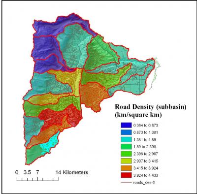
Road density (road length per unit area as in km/km2 or mi/mi2) is often used as a surrogate for road related impacts.
Road density is typically calculated at the scale of entire watersheds or subbasins. In the example here, road density at the scale of HUC 6th (12-digit) subbasins range from 0.3 to 4.4 km/km2. I
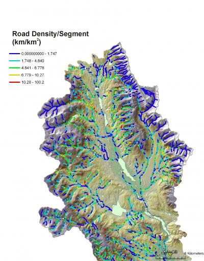
In TerrainWorks, road density can also be calculated at the scale of individual slices of hillslopes (referred to as “drainage wings”) and individual channel segments (50 – 200 m long). At that scale, road density becomes much more variable, ranging between zero and 100 km/km2, and provides a much more detailed perspective of where road density may be having the largest impacts on aquatic systems or on terrestrial wildlife.
Road Hydrologic Connectivity (Road Drainage Diversion)
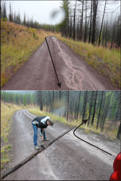
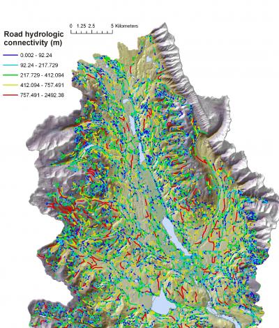
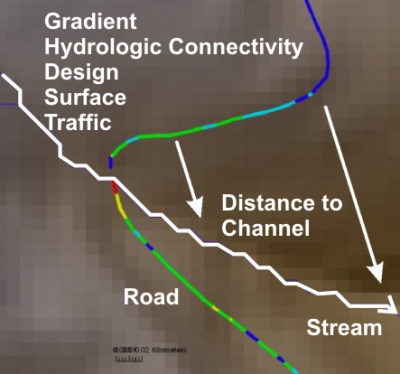
Roads that cross hillsides cross streams and also topographic high points and topographic low points. Consequently, roads collect drainage from surrounding hillsides and tend to concentrate it in ditches and then runoff is collected in culverts, water bars, rolling dips etc. and transferred to areas below the road. Hence, road hydrologic connectivity is important for road surface erosion, gully erosion and hillside stability (landsliding).
TerrainWorks (NetMap) has a tool to calculate road hydrologic connectivity using worse case assumptions (such as during storms or post wildfire) or more conservative when a program of culvert and water control measures are in place and functioning. In addition, if GPS locations of all culverts and other drainage structures are available, a user may use that data as input into the road hydrologic connectivity tool.
Road Surface Erosion
Road surface erosion (and sediment delivery to streams( is driven by the hydrologic connectivity of the road (length), road gradient, surface type, maintenance level, geometry (width, inslope, outslope), traffic level, soils distance of roads to streams and climate. TerrainWorks includes both the WEPP and the GRAIP-Lite models.
Road erosion predictions (delivered sediment to streams) can either be viewed on the road surface itself or in individual stream segments (NetMap applies both the WEPP and the GRAIP-Lite models).
Zeroing in on the Problem!
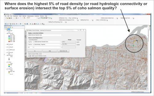
Once road surface erosion is calculated, a user can quickly locate spatial overlaps between roads with the highest road surface erosion potential (or highest road drainage diversion potential) and the most sensitive aquatic habitats. For example, using TerrainWorks Overlap Tool, a user can quickly determine where the top 5% of erosion potential overlaps the top 5% of coho fish habitat.
Road Stability
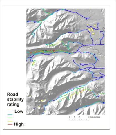
Roads on hillsides can contribute to slope instability, including shallow landsliding and debris flows, via road drainage (hydrologic connectivity), road cuts into hillslope materials and road fills. TerrainWorks can quickly classify all road segments (pixel scale) based on the predicted underlying stability of the hillside (see also the Slope Stability Application Page).
Cumulative Habitat Length (and quality) Above all Road–Stream Crossings
Roads can create migration barriers to fish because of excessive elevation drops at the mouths of culverts or because of gradient barriers (steeply sloping culverts). In the context of road maintenance and restoration, it would be very useful to know the cumulative habitat length and quality upstream of every single road-stream crossings at the scale of entire watersheds, private ownerships or national forests. TerrainWorks contains both habitat prediction tools and a road tool to quickly determine the habitat characteristics upstream of all road crossings.
Roads in Floodplains
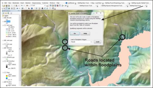
Many roads are located within floodprone areas or floodplains. Using NetMap's Floodplain Mapping Tool, users can quickly identify those road segments that are located within predicted floodplain areas or which road segments that have the highest predicted hydrologic connectivity or road surface erosion intersect floodplains.

