 Agencies, NGOs, universities and consultants have partnered with us to add NetMap's Virtual Watersheds, Smart River Networks and Analysis Tools to their projects in a cost-effective way.
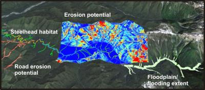
Projects can encompass:
 fish habitat typing/modeling
- mapping floodplains, terraces, and fans
- channel classification
- identifying biological hotspots
- predicting thermal loading and effects of riparian vegetation or management
- predicting wood recruitment to streams including the effects of forest management scenarios
- mapping erosion source areas - shallow failures, debris flows, surface erosion, gully, and earthflows
- delineating levels of risk between habitats and stressors
- developing sedment budgets (effects of land uses)
- determining highest risk areas for existing and future roads
- identifying locations of the highest combined wildfire-erosion risk, and where they overlap sensitive habitats
- conducting basin assessments/watershed analyses for various objectives including TMDLs, watershed restoration, conservation planning and resource use planning
- and other potential capabilities
Desktop Watershed Analysis
NetMap provides the digital infrastructure and analysis tools to underpin a “desktop watershed analysis.”
Questions that can be answered using NetMap
For more information, see Clients/Projects
TerrainWorks (NetMap) Applications
TerrainWorks supports numerous types of applications relevant to natural resources:
- Fisheries Management
- Forestry Management
- Riparian Management
- Slope Stability
- Erosion/Sediment Budgets
- Watershed Analysis
- Floodplain Mapping
- Grazing Analysis
- Pre-Wildfire Planning
- Post-Wildfire Planning
- Conservation
- Restoration (watershed or in-stream)
- Climate Change Vulnerability
- Regulatory Evaluation
- Total Maximum Daily Load (TMDL)
- Research
- Monitoring
- Energy Development
- Urban Planning
- Risk Management