Economical, Pre-Packaged Watershed Analyses
You can order and access Watershed AnalysisPackages by defining your geographic location, the size of the watershed or landscape of interest, and the analysis types of interest.
See what is covered in the Customizable Watershed Analysis Packages.
Go to Order Page
Or read more below
 TerrainWorks (NetMap) builds economical watershed assessments for pennies, rather than dollars per acre. Geographic scope of analysesrange from small tributaries to landscapes to entire states. How to use Watershed Analyses?
We are able to provide economical analyses because TerrainWorks (NetMap) efficiently builds and utilizes Virtual Watersheds across large geographic areas of the western US and beyond (What's a Virtual Watershed?).
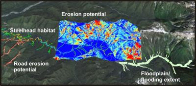
In addition to providing a wide range of watershed information, NetMap's assessments provide data on key watershed questions including:
►where are the best fish habitats located?
►which areas are most erosion prone and at greatest risk from land use?
►what road segments pose the greatest threat?
►which areas are most prone to wildfire and post-fire extreme events
►where are the greatest climate change impacts likely to occur?
►at what locations do multiple stressor overlap with the highest quality and most sensitive habitats?