 Understand Spatial Relationships between Urban Settings and Sensitive Habitats
Urban planning involves understanding relationships between built infrastructure (roads, homes, drainage systems etc.) and the natural environment including streams, rivers, floodplains, wetlands, estuaries and hillslopes, including those with erosion potential.
In addition, given the typical long history of urbanization and the resultant impacts on aquatic environments, planning often involves restoration, as well as protection.
The increasing availability of high resolution DEMs (LiDAR) in urban settings means that tools like TerrainWorks get more powerful. The ability to accurately map fish habitats, floodplains, estuaries and unstable slopes greatly increases. Tools in TerrainWorks that are particularly useful in urban settings include:
- fish habitats
- floodplains
- estuaries
- unstable slopes (and other types of erosion, including surface)
- habitat length and quality above all road crossings
- wildfire (wildland - urban interface; prefire, postfire)
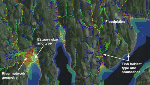
 Fish Habitats: Map the potential for different species (shown is an example from TerrainWorks (NetMap) in the Puget Sound (Dungeness Spit area).
 Use NetMap's Sort & Rank tool to create subbasin classification of various environmental properties such as fish habitats.
Identify Floodplains and Flood Prone Areas
 Map floodplains and floodprone areas, even those obscured by historical land use (agriculture). Shown is the lower Skokomish River floodplain in western Washington. Learn more.
Map Estuaries, Even Those Obscured by Land Use
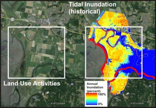
Map estuaries, including those long obscured by historical land uses. Shown is the Skagit River estuary in northwestern Washington.
Identify Intersections between Slope Instability and Urbanization
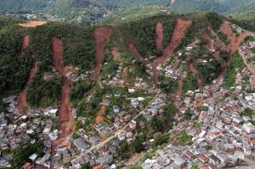
Predict slope instability and areas (homes, roads) at risk using a series of TerrainWorks (NetMap) tools. Learn more.
 Drape TerrainWorks predictions of shallow landslide potential and debris flow runout onto Google Earth.
 Use the tools to quickly identify where environmental stressors overlap high value habitats in urban settings. For example, where does the highest 5% of road density intersect the top 5% of fish habitat quality.
Create Unique Environmental Classification Schemes
 Create unique environmental classification schemes tailored to specific landscape-urban settings. For example, in the Puget Sound (Washington State), combine TerrainWorks (NetMap) predictions of aquatic habitats, floodplains and estuaries. Delineate the areas of highest combined habitat potential or biological hotspots.