
Slope Stability Risk Management
Effective risk mitigation requires accurate identification and mapping of slope instability features. Landslides and debris flows represent serious risks to homes, highways and fish and wildlife habitats. Slope stability analysis has applications in forestry, restoration, fishery management, wildfire planning, urban planning, watershed management, and climate change.
In support of slope stability analysis, NetMap's prediction tools cover:
- shallow landslide
- debris flow
- gullying
- earthflows/deep seated landslides
See more landslide hazard maps.
Numerical modeling of landslide and debris flow risk.
Climate change may increase landslide risk.
Shallow Landslide


NetMap's prediction of shallow landslide potential uses the topographic index Generic Erosion Potential, which is based on slope gradient, drainage area per unit contour length and hillslope curvature. See an application of NetMap's shallow landslide and debris flow model to the right. (A) The layout of topography, forest harvest and the location of a home. (B) A shallow landslide occurred and triggered a debris flow, prior to the advent of widely available slope stability maps. (C) NetMap's shallow landslide prediction would have accurately identified the failed hillside as high risk. (D) Other headwater streams in the vicinity are also predicted to be of high risk for debris flows.

Debris Flow
Although field work and use of aerial photography are important pieces in a geologist's tool box for identifying slope stability concerns in resource development, NetMap's screening tools can provide a quick and effective means to evaluate landslide and debris flow risk at the scale of entire watersheds or landscapes.
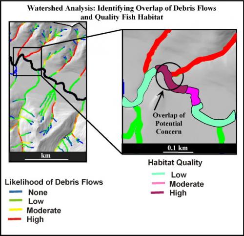
Maps of debris flow susceptibility at the watershed scale allow users to quickly identify high risk headwater streams and the important resources they can impact. Analysts can examine the along-channel risk of debris flows (A) or search for locations where higher debris flow risk intersect valuable resources (B).
Note, the maps represent "generic" landslide and debris flow potential. Calibrating landform and other criteria to landslide inventory data is the best means to generate the most accurate landslide hazard maps, including using LiDAR where available.
Watershed Classification of Risk
 Analysts can use NetMap tools to drape predictions of debris flow risk onto Google Earth (see TerrainWorks Viewer).
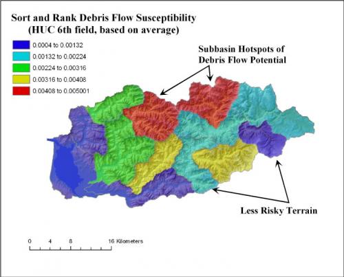
In addition, NetMap can be used to classify landslide and or debris flow risk at the scale of individual subbasins using the Sort and Rank Tool.
Search for Intersections between Erosion Risk and Vulnerable Habitats
 Use NetMap's tools and Digital Hydroscape to quickly find where the highest slope stability risk intersects the highest ranked aquatic habitats or where landslide and debris flow risks intersect important resources such as roads, homes, fish habitats or other infrastructure
 .
.