Digital Hydroscape & Tools
What's included?
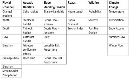 NetMap datasets come loaded with a set of useful attributes
covering:
-Fluvial Environments
-Aquatic Habitats
-Slope Stability/Erosion
-Roads
-Wildfire
-Climate Change
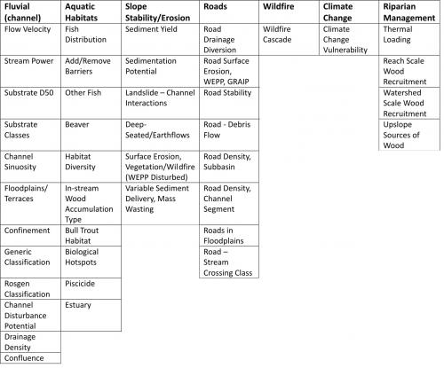 NetMap tools are used to quickly calculate a range of other attributes.
Other tools support:
-Subbasin classification
-Risk Assessment
-Wildfire Pre and Post Analysis
-Climate Change Vulnerability
-Restoration Planning
-Riparian Management
-Watershed Delineation
-TerrainViewer ("The Big Picture")
Access the Digital Hydroscape With Tools
Over 100 watershed and river parameters.
Test Drive the Tools and Digital Hydroscape
See What's Under the Hood
What Kinds of Questions Can the Digital Landscapes and Analysis Tools Answer?
Note: Custom Digital Landscapes can be Created (DEM resolutions, boundaries, and sizes): Contact us for more details.
Explore the Digital Hydroscape
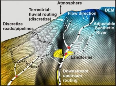
A Digital Hydroscape is a terrain model where all terrestrial and riverine surfaces are characterized and connected along physically and biologically relevant pathways. The Digital Hydroscape places past, present and future land uses in context with natural processes and landforms to identify habitat stressor interactions and to optimize resource use, risk mitigation, restoration and conservation planning.
Learn more about Digital Landscapes.
 Explore The Analysis Tools
See More Details:
-Roads (Energy)
Access the Digital Hydroscape With Tools