NetMap Analyses can address:
 Fish habitats-forest roads-road drainage-road erosion-migration blockages
- Fish habitats-forests-landslide potential
- Aquatic habitats and riparian management related to thermal loading and large woody debris transport
- Wildfire-erosion-water quality-fish habitat
- Sensitive terrestrial and aquatic habitats overlapping with single to multiple stressors
- Landslides-debris flows-risk to homes and highways
- Rivers-sedimentation-flooding risk
- Biological hotspots: the intersection with human activities
- Riparian Management (define riparian zones), effects of current shade on thermal energy, watershed scale wood recruitment and thermal refugia

User - Friendly Tools
TerrainWorks contains six analysis modules (add-ins in ArcMap 10.x) that encompasses 97 tools and over 100 parameters. The modules include:
- Analysis and Data Management
- Fluvial Processes
- Aquatic Habitat
- Riparian Environments
- Erosion
- Transportation/Energy
- WildFire/Climate
TerrainWorks provides up-to-date digital landscapes and analysis tools, accessed by modest annual subscriptions, similar to other modern software, thereby assuring its long-term sustainability, maintenance, and evolution.
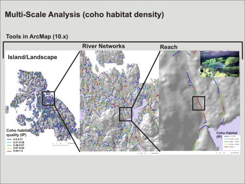
Multi-Scale Analysis

Interactions between landscapes and human land uses play out across spatial and temporal scales. TerrainWorks provides data and analysis tools that analyze landscapes and watersheds across spatial scales. The online TerrainViewer summarizes various landscape and land use information at the scale of Hydrologic Unit Codes (HUC) 4 through 6th field (8 through 12 digit), specifically for the larger scales of landscapes, states, and regions. In addition the TerrainViewer provides data summarization at the scale of agency jurisdictions, presently US Forest Service National Forests and Districts.

In addition, the Arc tools provide analysis capabilities at the watershed (HUC 4), subbasin (HUC 6) and at the individual hillside and stream reach scale.
Although the spatial scale of individual stream reaches and hillsides is important, patterns of landscape attributes and land uses aggregated up to larger scales of tributaries and entire watersheds are also relevant. A subscription to TerrainWorks (NetMap) includes access to the TerrainViewer, an online tool (non-ArcGIS) that displays information on environmental attributes and interactions with land use activities aggregated up to tributary-watershed scales of Hydrologic Unit Code (HUC) scales 4 through 6 . In addition, agency-specific hierarchical scales for the US Forest Service (Region – Forest – District) are included in the tool.
Search for Stressor - Habitat Overlaps

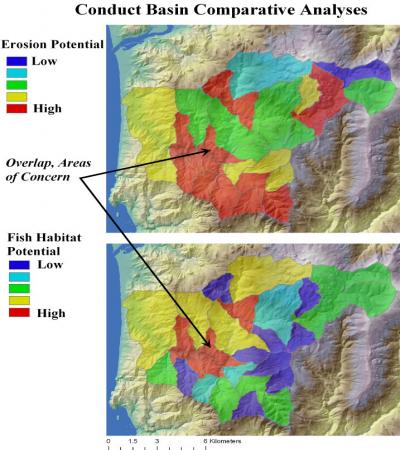
In addition to displaying data, The TerrainWorks Viewer online tool is also used to search for overlaps habitats and environmental stressors. A user searches where a chosen percentile of the frequency distribution of attributes (at each specific scale using a HUC or agency jurisdiction) overlaps with another chosen percentile for another attribute. For example, at the scale of HUC 6 (12 digit) tributary basins in a national forest, where does the top 5% of wildfire risk intersect the top 10% of fish habitat quality and where does that pair intersect with the top 5% of road density? This type of analysis can be conducted across scales providing an unprecedented understanding of where problem areas may exist at the scale of landscapes and watersheds and/or US Forest Service jurisdictions extending from the Region to Forest to District.
Check it Out
