Integrating Wet Areas Mapping with NetMap's Virtual Watershed to Support Spatially Explicit Riparian Zone Delineation and Management in Alberta.
 Abstract
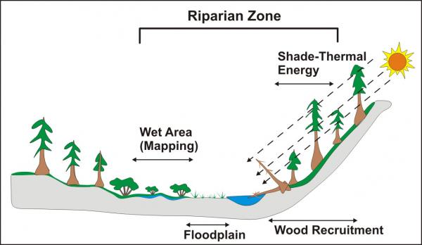
Two advanced watershed analysis technologies, Alberta’s Wet Areas Mapping (WAM) and NetMap’s virtual watershed coupled to tools, are combined to create a state of the art platform for various types of watershed analyses. Spatially explicit riparian zone delineation and management require information on selected riparian processes and on environmental settings – e.g., those watershed conditions that influence how riparian processes affect aquatic habitats. Selected riparian processes in the Integrated WAM-NetMap in the Simonette River pilot project area include: (1) depth to water or wet areas (WAM), (2) floodplains, (3) current vegetative shade effects on thermal energy to streams and (4) in-stream wood recruitment. Environmental settings can include channel types, habitat types, hillslope erosion potential, channel migration zones, thermal refugia, tributary confluences, wildfire risk and climate change; however, the demonstration analysis of delineating spatially explicit riparian zones in the Simonette River pilot area does not include the environmental setting component, although it could be added in the future by other analysts. Attributes in the WAM-NetMap that support riparian zone delineation and environmental settings include drainage area, channel gradient, bankfull width, bankfull depth, and floodplain extent, among many others.
Delineating riparian zones using the Integrated WAM-NetMap in the Simonette River pilot project area involved user selected sets of riparian processes (one through four as listed above). Individual riparian zone dimensions associated with selected riparian processes are combined to create a single, composite riparian zone with left-right channel distinction. However, riparian zones associated with each riparian process can be limited in extent laterally according to user specified constraints on depth to water threshold and width of the WAM, width of the floodplain and proportion of in-stream wood protected (e.g., some proportion of a tree height). The spatially explicit delineation of variable-width riparian zones provides a robust approach to riparian zone management that distributes protection based on site ecological processes, resource economics, recovery of environments following disturbances and the increasing susceptibility of riparian forests to fires, insects, disease and other factors related to climate change.
Contact us for additional information.