 In concept, a Virtual Watershed environment supports analysis of physical and biological processes, and human interactions.
In practice, a Virtual Watershed encompasses a numerical data structure, operating within a GIS, that has an architecture designed to quantify physical and biological processes and human interactions over a range of scales.
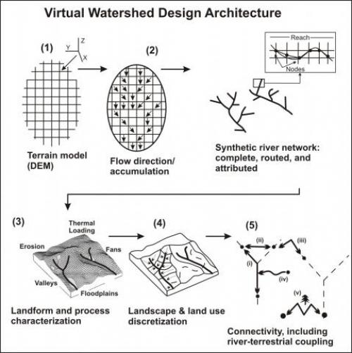
A Virtual Watershed, also referred to as a "digital hydroscape" is characterized by five benchmark elements:
1) digital elevation or digital terrain models,
2) routed and attributed synthetic stream layer,
3) landform and process characterization,
4) landscape and land use discretization and
5) connectivity, including river-terrestrial coupling (Miller 2002, Clarke et al. 2008).
One evolving form of the hydroscape within a decision support system, NetMap (Benda et al. 2007), is designed to address aquatic oriented resource management and conservation questions and to broaden access of those capabilities to larger stakeholder groups in a community setting (Miller 2002, Benda et al. 2007, Clarke et al. 2008, Miller and Burnett et al. 2007, 2008, Benda et al. 2009, 2011, Barquin et al. 2011, McCleary et al. 2011, Fernandez et al. 2012a, Pickard 2013, Ji et al. 2013, Bidlack et al. 2014).
The synthetic river network in a Virtual Watershed is the integrating feature, just like in real watersheds, and it supports analyses of connectivity and routing including: 1) downstream, 2) upstream, 3) across valley, 4) downslope - upslope, 5) terrestrial - river and 6) land surface - atmosphere.
In the Virtual Watershed, past, present and future land uses can be placed in context with natural processes and landforms to identify habitat stressor interactions and to optimize resource use, risk mitigation, restoration and conservation planning.
Read more about Virtual Watersheds.
NetMap's virtual watershed underpins:
Watershed Assessments
Community NetMap Tools ; Learn about their applications
Our Unique Analyses
Learn how virtual watersheds are built (step by step, through a PPT)
Learn more about how virtual watersheds or hydoscapes underpins the Community Based Tool Development and the Future of Applied Watershed Science.
Learn more about synthetic stream layers.
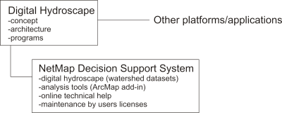 Relationship between Virtual Watersheds and NetMap
Virtual watersheds or hydroscapes stand alone in concept and design architecture. The hydroscape's benchmark set of five elements is integrated within the NetMap
Decision Support System consisting of the unique combination of consistent
watershed datasets (e.g., digital hydroscapes), community based analysis tools,
online technical help and its bottom up sustainability via users licenses.