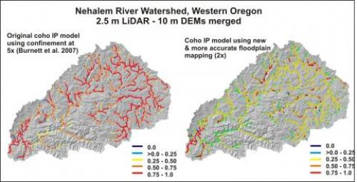
 Moving from the original IP models that use valley width at 5x bankfull depth with 10 m DEMs to LiDAR DEMs using the latest NetMap technology using floodplains at 2x bankfull depth creates the largest improvement in accuracy and detail.
If you have LiDAR based NetMap datasets, learn how to recalculate your habitat intrinsic potential values, specifically for coho and steelhead.
Building new IP maps using LiDAR in NetMap requires new LiDAR based NetMap datasets. Contact us to see if they already exist. If they do not, TerrainWorks can build new LiDAR based NetMap datasets and create new habitat IP maps. Contact us for details.