The Digital Hydroscape Works with NetMap Tools
 A digital hydroscape, developed by TerrainWorks, provides the numerical underpinning for all of NetMap's watershed assessments and analysis tools.
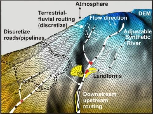
The digital hydroscape is a state of the art terrain model where all terrestrial and riverine surfaces are characterized and connected along physically and biologically relevant pathways. The digital hydroscape includes a synthetic stream network (stream layer) that is heavily attributed and supports downstream-upstream routing and riverine-terrestrial linkages and data transfer.
The digital hydroscape is required for NetMap Tools and supports analyses of aquatic and terrestrial ecosystems, including fish habitats, floodplains, riparian functions, slope stability, wildfire, erosion, roads and climate change, all in the context of human land uses.
In the digital hydroscape, past, present and future land uses can be placed in context with natural processes and landforms to identify habitat stressor interactions and to optimize resource use, risk mitigation, restoration and conservation planning.
See more details in a PPT, step through the slides.
Learn more about Digital Hydroscapes.
Learn more about synthetic stream layers.
Read More below:
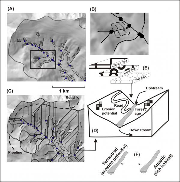 NetMap's digital hydroscape goes well beyond just a stream layer. (A) A hydroscape contains a synthetic, attributed and routed river network with individual river segments delineated (black dots are tributary confluences). (B) Each river segment delineates a local contributing area (LCA) on both sides of the channel (often referred to as "drainage wings"). (C) The entire hydroscape is discretized into LCAs; river segments of 100 to 200 m create LCAs of approximately 0.1 km2. Linear features such as roads and pipelines are discretized at pixel scales and associated with similarly scaled indices of other attributes such as erosion. (D) Each LCA creates similarly scaled terrestrial information including roads, erosion potential, wildfire risk and climate change attributes etc. depending on the models and tools linked to the hydroscape. (E) Other data layers can be added such as water bodies, basin boundaries, lithology, soils, vegetation and climate and treated as landscape features to be discretized, routed, and analyzed via connectivity pathways within a hydroscape. (F) Terrestrial attributes are mapped as channel data and overlaid onto stream attributes such as sensitive habitats. All types of data can be routed downstream (or upstream) revealing patterns at any spatial scale defined by the network.
Each terrestrial point, or grid cell in a hydroscape, is represented by x, y and z coordinates, and is referenced to a point in the fluvial network by overland flow paths. Each river grid cell is referenced to all upstream and downstream river cells. Thus all river and terrestrial cells within a catchment form a data-transfer network that includes the downstream, upstream, down-slope and up-slope transfer of information, ranging from physical and biological processes (such as erosion) to spatial patterns of land use.
The spatial grain of the Digital Hydroscape is set by the resolution of the DEM, although larger cell sizes can be derived from finer-scale data. The hydroscape allows for comprehensive analysis of spatial patterns and relationships in watersheds (or across landscapes) that can support many types of analyses that are relevant to resource management and environmental protection.
Methods
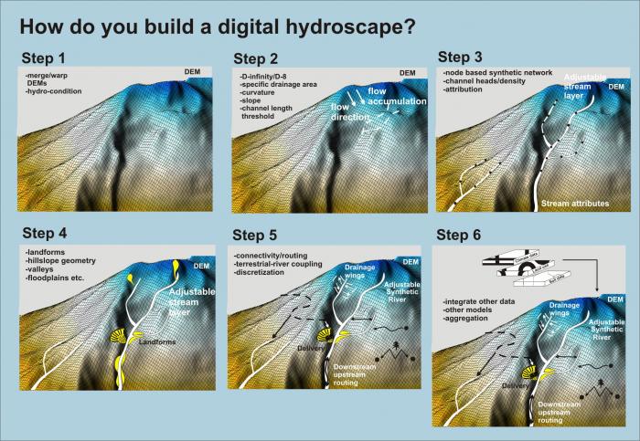
Computer algorithms build the hydroscape using the following steps: (1) merging DEMs from different sources, which may be of different resolution and accuracy, (2) smoothing the surface, (3) removal of closed depressions - hydro condition (temporarily), (4) predicting surface flow directions to create flow direction grids, (5) delineating a synthetic channel network (can require channel extent and channel-density calibration), (6) mirroring digital and optical representations of stream networks, (7) defining channel segmentation, (8) delineating local contributing areas (LCAs) to stream segments, (9) attributing channel segments with watershed- and reach-scale data (elevation, drainage area, gradient, etc.), (9) delineating catchment and subbasin boundaries, (10) transferring data from geo-referenced field information, and (11) transferring data from other digital representations of river networks.
In the digital hydroscape, river networks can be customized. Networks can be trimmed from the headwaters, either globally or by individual segments (requires NetMap Tools). Subscribers can access the core tools for rebuilding their river networks and customizing it. Contact us for details.