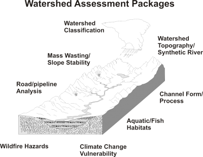
 Watershed Assessment Packages include a combination of grids (rasters) and in-channel attributes (reach and routed downstream) to facilitate interdisciplinary studies and risk assessments. See Information types. Data can also be in jpeg formats.
Videos show how the tools are used to generate the Watershed Assessments.
(1) Watershed Topography (n = 6 attributes)
(2) Channel Form/Process (n = 9 attributes)
- Geometry (bankfull width, depth) ?
- Mean annual flow ?
- Channel gradient ?
- Stream order ?
- Stream power ?
- Drainage area ?
- Floodplain width ?
- Channel classification (source, transport, response) ?
(3) Aquatic (Fish) Habitats (n=7); see video
- Coho salmon Intrinsic Potential (IP) ?
- Chinook salmon IP ?
- Steelhead IP ?
- Westslope cutthroat IP ?
- Beaver habitat ?
- Biological hotspots ?
- Channel Disturbance Index ?
(4) Mass Wasting/Slope Stability (n=16 attributes); see video
- Warning (use of geotechnical information) ?
- Shallow landslide, all and delivered to streams* ?
- Shallow landslide hazard proportion* ?
- Debris flow* ?
- Debris flow source areas* ?
- Debris flow - fish streams* ?
- Gully erosion (grid) ?
* Local calibration to landslide/debris flow data
(increases accuracy - contact us)
(5) Watershed Classification Systems ? see video
- Build cumulative distributions of any watershed attribute at any scale
- Using distributions, classify any attribute at the scale of customized subbasins
(6) Road/pipeline Analysis (n= 7 attributes); See video (provide your own road layer or ask us)
- Road density (subbasin) ?
- Road density (channel segment-drainage wing) ?
- Road drainage diversion ?
- Road erosion and sediment delivery to streams ?
- Road - hillslope stability relationships (landslide) ?
- Road - debris flow intersections ?
- Roads in floodplains ?
- Habitat length and quality above all road crossings ?
(7) Wildfire Hazards (n = 9 attributes); see video
- Wildfire severity (grid, stream reach and routed) ?
- Wildfire probability (" ") ?
- Post fire erosion (" ") ?
(8) Climate Change Vulnerability (n=15 attributes); see video
- Temperature - change from historical (grid, stream reach and routed) ?
- Precipitation - (" ") ?
- Snow accumulation - (" ") ?
- Summer runoff - (" ") ?
- Winter runoff - (" ") ?
- Snow-water equivalent ?
(9) Habitat - Stressor Overlaps; see video
- Watershed Assessments come with NetMap's Quick Tool (as an ArcMap 10.x add-in)
- Using Quick Tool, generate maps and tables where the greatest stressors (landslide potential, road erosion, wildfire risk, post fire
erosion, and climate change) overlaps, either singly or in combination, with the most important and sensitive
habitats. For example, where does the top 5% of predicted road surface erosion overlap with the top 5% of fish
habitat quality?
Contact us to order and customize your Watershed Assessments by: a) requesting a specific geographic location and area (size) and b) by selecting from a set of analyses packages below. Go here.
