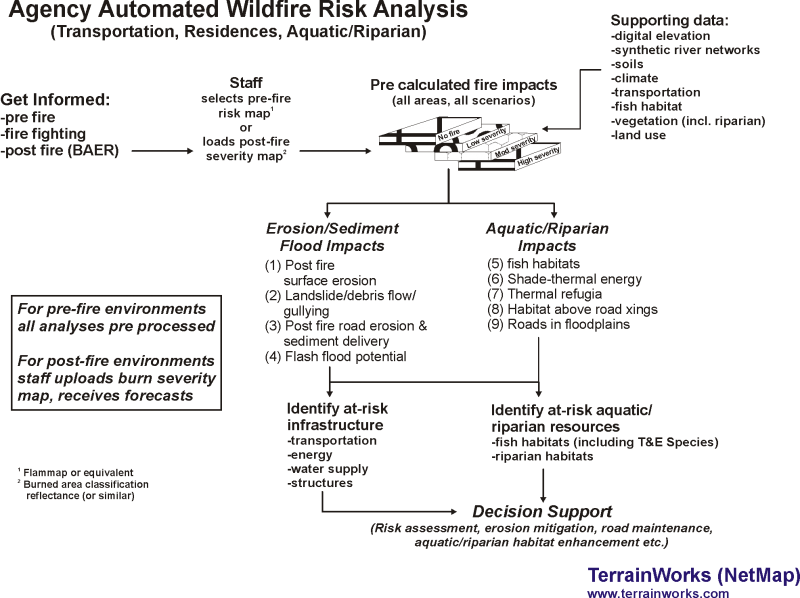
Decision Support in Pre Wildfire and Post Wildfire Planning, and Firefighting: Identify At-Risk Infrastructure and Aquatic/Riparian Habitats
(Inform risk assessment, erosion mitigation, road maintenance and aquatic/riparian enhancement etc. at the scale of counties, watersheds, national forests, landscapes and states)
For Pre-fire pilot analysis in the Malheur National Forest:
See online PPT-PDF
For Post-fire pilot analysis of the Canyon Creek Complex Wildfire (eastern Oregon, September 2015) using actual burn severities (BARC)
See online PPT-PDF
Contact us to set up your own automated (pre run) wildfire analyses, that includes using post fire burn severity maps.
Resource planners, fire control staff, community planners and fire fighters require information to inform pre wildfire forest and road management and post fire restoration efforts to protect valuable infrastructure (structures, transportation, energy, water supply) and aquatic/riparian systems across forests in the western United States. Information at the scale of watersheds, landscapes and national forests should include:
- Where forest restoration could reduce fire related impacts to critical built infrastructure and fish/riparian habitats.
- Where road maintenance and restoration could reduce fire related impacts on aquatic systems, water quality and infrastructure.
- Where firefighting, including use of retardant, would be most effective at protecting critical aquatic and riparian habitats.
At the scale of communities, counties, watersheds, national forests and states, a set of data products is needed to guide forest restoration (pre wildfire), real time firefighting, and post fire emergency response to enhance protection of important infrastructure and aquatic/riparian habitats. Advanced terrain modeling (NetMap), combined with currently available pre-event wildfire predictions (fire probability and intensity) or post fire burn severity maps, is used to identify key locations: (1) where forest fuels reduction and stand structure modifications could contribute to protection of important infrastructure (homes, highways, transportation, energy, water supply) and to aquatic systems, including threatened and endangered species, (2) where improvements to forest roads through new surfacing and drainage structures, and storage, would achieve the greatest pay back for protecting infrastructure and fish habitats, including increasing migration and access to new habitats, (3) where firefighting could be strategically applied to reduce losses of critical fish and riparian habitats and (4) where post-fire restoration would have the largest beneficial effects on reducing erosion and flood impacts to infrastructure and aquatic/riparian habitats. This could include increasing options for use of retardant to protect key aquatic and riparian environments.
Advanced terrain modeling for informing forest and road restoration, and firefighting, would provide data products to resource specialists, including:
- Improved digital stream networks, focusing on locations of critical fish and riparian habitats
- Predicted fire probability and fire severity (flame length) or post-fire burn severity data mapped to river networks
- Post fire accelerated surface erosion and sediment delivery to streams and other water bodies
- Landsliding, debris flows and gullying
- Flash flood potential
- Post fire changes to forest road erosion and sediment delivery to streams
- Post fire changes to riparian shade and thermal energy to aquatic habitats
- Post fire changes to aquatic thermal refugia
- Overlaps among all fire-related stressors and important infrastructure and fish/riparian habitats.
Data products are in the form of GIS data layers (shapefiles). A fire stressor-resource overlap tool is provided (add-in in ArcMap 10.x) to support use of the data layers in pre fire planning, post fire restoration and firefighting. Data layers used in post fire environments identify critical locations where predicted accelerated erosion and flooding pose risks to infrastructure and valuable riparian and aquatic habitats at the scales of communities, counties, watersheds, national forests and states. Technical support include printed and video media (and technical help and meta data).
Interested in learning more, contact us.

