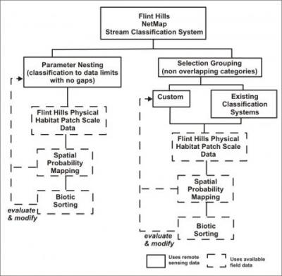
 A new stream (and biotic) classification system was built into NetMap for the US Fish and Wildlife Service . The classification system consists of four components: 1) “Parameter Nesting” that uses nested sets of remote sensing parameters to ensure classification to the upstream to downstream limits of the river networks and data, 2) “Selection Grouping” that allows for flexible combinations of parameter ranges to build classifications, 3) “Spatial Probability Mapping” that converts field data on patch-scale habitat features to measures of feature density and for its extrapolation across all Flint Hill channel segments using remote sensing data, and 4) “Biotic Sorting” that categorizes field data on fish and mussel species and their abundance by channel classes. Parameter nesting uses up to three parameters and two class breaks per parameter for a maximum of eight classes and it ensures classification to river network and data limits with no gaps. Selection Grouping is not limited to the number of parameters and gaps and partial stream classification is allowed. Both systems create non overlapping channel class types and allow use of the full suite of remote sensing channel attributes that totals approximately 24 in various combinations. Parameter Nesting and Selection Grouping utilize cumulative distribution functions of channel attributes to help guide selection of parameter class breaks. Since the primary goal of the Flint Hills channel geomorphic classification system is to inform classification of aquatic biota, the system requires the ability to explore classification fidelity and is applied iteratively.
To see full report and description of the new NetMap classification tools, go here.
