Access the Digital Hydroscape to Build Your Own Applications
 Learn more about Digital Hydroscapes
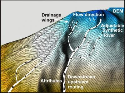
Digital Landscapes consists of:
-Digital elevation model (singular or merged)
-shaded relief
-elevation grid
-slope grid
-flow direction grid
-flow accumulation grid
-curvature grid
-stream layer (synthetic) What's this?
-drainage wings (what's that?)
Routing capabilities: downstream - upstream, terrestrial - riverine
See how we build the Digital Hydroscape.
You get access to the TerrainViewer.
Get Digital Landscapes: Three steps:
►Step 1: Select Geographic Location: WA, OR, ID, MT, CA, WY, NV, SD, ND, plus areas in Southeast and Southcentral Alaska. Check availability. Digital landscapes not available? We can build new ones. Want to use different DEMs? Contact us.
►Step 2: Define Area: Customizable, ranging from parcels to entire states.
►Step 3: Send us your information (1-2) and get a price quote.